
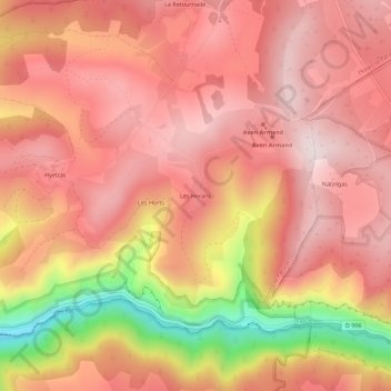
Les Herans topographic map
Interactive map
Click on the map to display elevation.
About this map
Name: Les Herans topographic map, elevation, terrain.
Average elevation: 2,940 ft
Minimum elevation: 1,831 ft
Maximum elevation: 3,435 ft
Other topographic maps
Click on a map to view its topography, its elevation and its terrain.
Hyelzas
France > Occitanie > Lozère > Hures-la-Parade
Hyelzas, Hures-la-Parade, Florac, Lozère, Occitanie, France métropolitaine, 48150, France
Average elevation: 2,841 ft
Nivoliers
France > Occitanie > Lozère > Hures-la-Parade
Nivoliers, Hures-la-Parade, Florac, Lozère, Occitanie, France métropolitaine, 48150, France
Average elevation: 3,360 ft
Drigas
France > Occitanie > Lozère > Hures-la-Parade
Drigas, Hures-la-Parade, Florac, Lozère, Occitanie, France métropolitaine, 48150, France
Average elevation: 3,386 ft
Les Douzes
France > Occitanie > Lozère > Hures-la-Parade
Les Douzes, Hures-la-Parade, Florac, Lozère, Occitanie, France métropolitaine, 48150, France
Average elevation: 2,638 ft
Le Villaret
France > Occitanie > Lozère > Hures-la-Parade > Le Villaret
Le Villaret, Hures-la-Parade, Florac, Lozère, Occitanie, France métropolitaine, 48150, France
Average elevation: 3,346 ft