
Carrandi topographic map
Interactive map
Click on the map to display elevation.
About this map
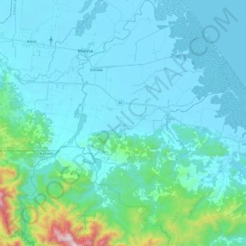
Name: Carrandi topographic map, elevation, terrain.
Location: Carrandi, Cantón Matina, Provincia Limón, 70503, Costa Rica (9.89119 -83.29982 10.12525 -83.15041)
Average elevation: 427 ft
Minimum elevation: -7 ft
Maximum elevation: 3,720 ft
Other topographic maps
Click on a map to view its topography, its elevation and its terrain.
Río Matina
Costa Rica > Provincia Limón > Carrandí
Río Matina, Carrandí, Cantón Matina, Provincia Limón, 70503, Costa Rica
Average elevation: 26 ft