
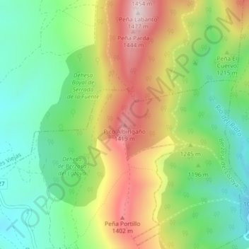
Pico Albirigaño topographic map
Interactive map
Click on the map to display elevation.
About this map
Name: Pico Albirigaño topographic map, elevation, terrain.
Average elevation: 3,940 ft
Minimum elevation: 3,346 ft
Maximum elevation: 4,797 ft
Other topographic maps
Click on a map to view its topography, its elevation and its terrain.
Berzosa del Lozoya
España > Comunidad de Madrid > Berzosa del Lozoya
Berzosa del Lozoya, Sierra Norte, Comunidad de Madrid, España
Average elevation: 3,524 ft