
Le Brasq topographic map
Interactive map
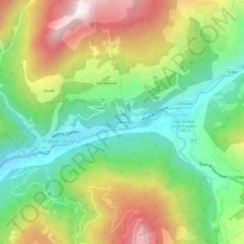
Click on the map to display elevation.
About this map
Name: Le Brasq topographic map, elevation, terrain.
Average elevation: 5,643 ft
Minimum elevation: 4,324 ft
Maximum elevation: 7,592 ft
Other topographic maps
Click on a map to view its topography, its elevation and its terrain.
Prats Bas
France > Provence-Alpes-Côte d'Azur > Hautes-Alpes > Château-Ville-Vieille > Ville-Vieille
Prats Bas, Ville-Vieille, Château-Ville-Vieille, Briançon, Hautes-Alpes, Provence-Alpes-Côte d'Azur, France métropolitaine, 05350, France
Average elevation: 6,037 ft
La Casse
France > Provence-Alpes-Côte d'Azur > Hautes-Alpes > Château-Ville-Vieille > Ville-Vieille
La Casse, Ville-Vieille, Château-Ville-Vieille, Briançon, Hautes-Alpes, Provence-Alpes-Côte d'Azur, France métropolitaine, 05350, France
Average elevation: 5,722 ft