
Angoda topographic map
Interactive map
Click on the map to display elevation.
About this map
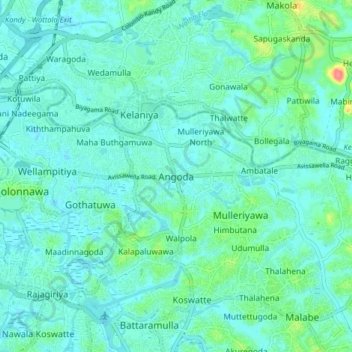
Name: Angoda topographic map, elevation, terrain.
Location: Angoda, Colombo District, Western Province, 10620, Sri Lanka (6.89602 79.88572 6.97602 79.96572)
Average elevation: 39 ft
Minimum elevation: -7 ft
Maximum elevation: 213 ft
Other topographic maps
Click on a map to view its topography, its elevation and its terrain.
Belagama
Sri Lanka > Western Province > Angoda
Belagama, Angoda, Colombo District, Western Province, 10620, Sri Lanka
Average elevation: 33 ft