
Sterrebeek topographic map
Interactive map
Click on the map to display elevation.
About this map
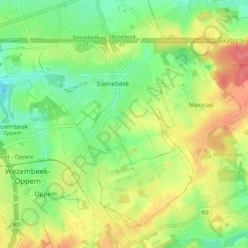
Name: Sterrebeek topographic map, elevation, terrain.
Average elevation: 236 ft
Minimum elevation: 138 ft
Maximum elevation: 364 ft
Other topographic maps
Click on a map to view its topography, its elevation and its terrain.
Sint-Stevens-Woluwe
Belgique > Brabant flamand > Hal-Vilvorde > Zaventem
Sint-Stevens-Woluwe, Zaventem, Hal-Vilvorde, Brabant flamand, 1932, Belgique
Average elevation: 194 ft