
Orme champêtre du causse Méjean topographic map
Interactive map
Click on the map to display elevation.
About this map
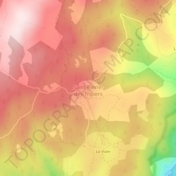
Name: Orme champêtre du causse Méjean topographic map, elevation, terrain.
Average elevation: 3,022 ft
Minimum elevation: 2,103 ft
Maximum elevation: 3,488 ft
Other topographic maps
Click on a map to view its topography, its elevation and its terrain.
Cassagnes
Frankreich > Okzitanien > Lozère > Saint-Pierre-des-Tripiers
Cassagnes, Saint-Pierre-des-Tripiers, Florac, Lozère, Okzitanien, Metropolitanes Frankreich, 48150, Frankreich
Average elevation: 2,362 ft