
La Valle topographic map
Interactive map
Click on the map to display elevation.
About this map
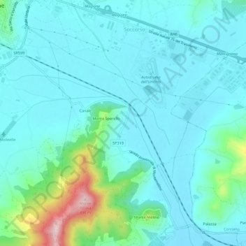
Name: La Valle topographic map, elevation, terrain.
Location: La Valle, Magione, Perugia, Umbria, 06063, Italia (43.10356 12.21265 43.14356 12.25265)
Average elevation: 869 ft
Minimum elevation: 725 ft
Maximum elevation: 1,594 ft
Other topographic maps
Click on a map to view its topography, its elevation and its terrain.
San Feliciano
Italia > Umbria > Perugia > Magione
San Feliciano, Magione, Perugia, Umbria, 06063, Italia
Average elevation: 906 ft
San Savino
Italia > Umbria > Perugia > Magione
San Savino, Magione, Perugia, Umbria, 06063, Italia
Average elevation: 974 ft