
پایین هلوسرا topographic map
Interactive map
Click on the map to display elevation.
About this map
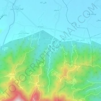
Name: پایین هلوسرا topographic map, elevation, terrain.
Location: پایین هلوسرا, بخش رانکوه, Amlash County, Gilan Province, Iran (37.02305 50.24439 37.06305 50.28439)
Average elevation: 453 ft
Minimum elevation: 52 ft
Maximum elevation: 1,804 ft
Other topographic maps
Click on a map to view its topography, its elevation and its terrain.
Shir Chak
Iran > Gilan Province > Amlash County > دهستان سمام
Shir Chak, دهستان سمام, بخش رانکوه, Amlash County, Gilan Province, Iran
Average elevation: 6,762 ft