
Saint-Antonin-Noble-Val topographic map
Interactive map
Click on the map to display elevation.
About this map
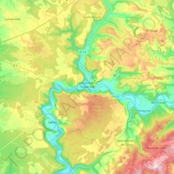
Name: Saint-Antonin-Noble-Val topographic map, elevation, terrain.
Average elevation: 922 ft
Minimum elevation: 348 ft
Maximum elevation: 1,716 ft
Other topographic maps
Click on a map to view its topography, its elevation and its terrain.
Perville
France > Occitania > Tarn-et-Garonne
Perville, Castelsarrasin, Tarn-et-Garonne, Occitania, Metropolitan France, 82400, France
Average elevation: 449 ft