
Qyteza Pejton topographic map
Interactive map
Click on the map to display elevation.
About this map
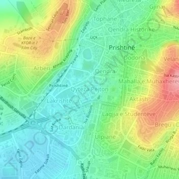
Name: Qyteza Pejton topographic map, elevation, terrain.
Location: Qyteza Pejton, Pristina, Municipality of Pristina, Kosovo (42.65516 21.15411 42.65980 21.16060)
Average elevation: 1,998 ft
Minimum elevation: 1,867 ft
Maximum elevation: 2,234 ft
Other topographic maps
Click on a map to view its topography, its elevation and its terrain.
Lakrishtë
Kosovo > Municipality of Pristina > Pristina
Lakrishtë, Pristina, Municipality of Pristina, Kosovo
Average elevation: 1,978 ft
Pristina
Kosovo > Municipality of Pristina > Pristina
Pristina, Municipality of Pristina, 10000, Kosovo
Average elevation: 2,280 ft