
Guadalupe Texcalac topographic map
Interactive map
Click on the map to display elevation.
About this map
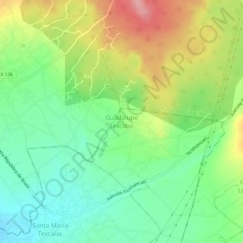
Name: Guadalupe Texcalac topographic map, elevation, terrain.
Location: Guadalupe Texcalac, Apizaco, Tlaxcala, 90430, México (19.41889 -98.09694 19.45889 -98.05694)
Average elevation: 8,077 ft
Minimum elevation: 7,897 ft
Maximum elevation: 8,356 ft
Other topographic maps
Click on a map to view its topography, its elevation and its terrain.