
สามพระยา topographic map
Interactive map
Click on the map to display elevation.
About this map
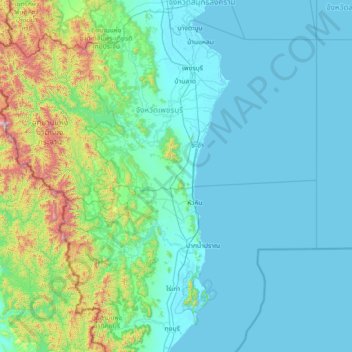
Name: สามพระยา topographic map, elevation, terrain.
Location: สามพระยา, Phetchaburi, Thailand (11.97613 99.18277 13.37613 100.58277)
Average elevation: 548 ft
Minimum elevation: -3 ft
Maximum elevation: 4,783 ft
Other topographic maps
Click on a map to view its topography, its elevation and its terrain.
หาดชะอำ
Thailand > Phetchaburi > สามพระยา > ชะอำ
หาดชะอำ, ชะอำ, นายาง, สามพระยา, Phetchaburi, Thailand
Average elevation: 10 ft