
Thank you for supporting this site ❤️
Make a donation
Make a donation
Gear up for your next adventure:
As an Amazon Associate, this site earns from qualifying purchases at no extra cost to you.
Sefiane topographic map
Click on the map to display elevation.
Thank you for supporting this site ❤️
Make a donation
Make a donation
Gear up for your next adventure:
As an Amazon Associate, this site earns from qualifying purchases at no extra cost to you.
About this map
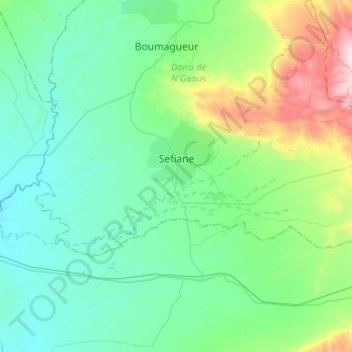
Name: Sefiane topographic map, elevation, terrain.
Location: Sefiane, N'Gaous district, Batna, 05064, Algeria (35.37865 5.45658 35.47620 5.71504)
Average elevation: 2,369 ft
Minimum elevation: 1,657 ft
Maximum elevation: 5,089 ft
Thank you for supporting this site ❤️
Make a donation
Make a donation
Gear up for your next adventure:
As an Amazon Associate, this site earns from qualifying purchases at no extra cost to you.