
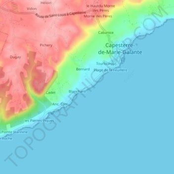
Vincent topographic map
Interactive map
Click on the map to display elevation.
About this map
Name: Vincent topographic map, elevation, terrain.
Average elevation: 151 ft
Minimum elevation: 0 ft
Maximum elevation: 541 ft
Other topographic maps
Click on a map to view its topography, its elevation and its terrain.
Dugay
France > Guadeloupe > Capesterre-de-Marie-Galante
Dugay, Capesterre-de-Marie-Galante, Pointe-à-Pitre, Guadeloupe, 97140, France
Average elevation: 341 ft
Pichery
France > Guadeloupe > Capesterre-de-Marie-Galante
Pichery, Capesterre-de-Marie-Galante, Pointe-à-Pitre, Guadeloupe, 97140, France
Average elevation: 325 ft
Rivière Saint-Louis
France > Guadeloupe > Capesterre-de-Marie-Galante > Sardé
Rivière Saint-Louis, Sardé, Capesterre-de-Marie-Galante, Pointe-à-Pitre, Guadeloupe, 97140, France
Average elevation: 374 ft