
Grand Portage National Monument topographic map
Interactive map
Click on the map to display elevation.
About this map
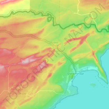
Name: Grand Portage National Monument topographic map, elevation, terrain.
Average elevation: 1,030 ft
Minimum elevation: 535 ft
Maximum elevation: 1,722 ft
The portage begins on Lake Superior, elevation 600 feet (180 m), rising as it moves westward through two notches in the Sawtooth Mountain range. It briefly levels off around 1,000 feet (300 m) after 2.6 miles (4.2 km). Another 1.5 miles (2.4 km) you reach the inland county highway. From here, the trail is more level, rising to 1,300 feet (400 m), the highest location on the trail, before dropping back to 1,260 feet (380 m) at Fort Charlotte on the Pigeon River. The trail's high point is the head of a drainage flowing to the Pigeon River at Fort Charlotte. The headwaters has become a large beaver pond. The dam is located along the trail route and has a boardwalk atop it, added for modern visitors.
Other topographic maps
Click on a map to view its topography, its elevation and its terrain.
Schroeder
United States > Minnesota > Cook County
Schroeder, Schroeder Township, Cook County, Minnesota, United States
Average elevation: 771 ft
Grand Marais
United States > Minnesota > Cook County
Grand Marais, Cook County, Minnesota, United States
Average elevation: 919 ft
Magic Lake
United States > Minnesota > Cook County
Magic Lake, Schroeder Township, Cook County, Minnesota, United States
Average elevation: 1,850 ft
Ptarmigan Lake
United States > Minnesota > Cook County
Ptarmigan Lake, West Cook, Cook County, Minnesota, United States
Average elevation: 2,008 ft
Lutsen
United States > Minnesota > Cook County
Lutsen, Lutsen Township, Cook County, Minnesota, 55612, United States
Average elevation: 738 ft
Cherokee Lake
United States > Minnesota > Cook County
Cherokee Lake, Cook County, Minnesota, United States
Average elevation: 1,854 ft
Olso Lake
United States > Minnesota > Cook County
Olso Lake, Cook County, Minnesota, United States
Average elevation: 1,785 ft
Hovland
United States > Minnesota > Cook County
Hovland, East Cook, Cook County, Minnesota, 56606, United States
Average elevation: 741 ft
Ball Club Lake
United States > Minnesota > Cook County
Ball Club Lake, Cook County, Minnesota, United States
Average elevation: 2,001 ft
Tofte
United States > Minnesota > Cook County
Tofte, Tofte Township, Cook County, Minnesota, 55613, United States
Average elevation: 732 ft
Flour Lake
United States > Minnesota > Cook County
Flour Lake, Cook County, Minnesota, United States
Average elevation: 1,755 ft
Grand Portage
United States > Minnesota > Cook County
Grand Portage, Cook County, Minnesota, 55605, United States
Average elevation: 843 ft
Eagle Mountain
United States > Minnesota > Cook County
Eagle Mountain, Cook County, Minnesota, United States
Average elevation: 1,955 ft
Chippewa City
United States > Minnesota > Cook County > Chippewa City
Chippewa City, Cook County, Minnesota, United States
Average elevation: 781 ft
Potato Lake
United States > Minnesota > Cook County
Potato Lake, East Cook, Cook County, Minnesota, United States
Average elevation: 2,037 ft