
Boulhaf Dir topographic map
Interactive map
Click on the map to display elevation.
About this map
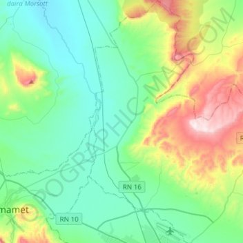
Name: Boulhaf Dir topographic map, elevation, terrain.
Location: Boulhaf Dir, daïra El Kouif, Tébessa, Algérie (35.42127 8.03828 35.62398 8.19427)
Average elevation: 2,989 ft
Minimum elevation: 2,379 ft
Maximum elevation: 4,823 ft