
Make a donation
Gear up for your next adventure:
As an Amazon Associate, this site earns from qualifying purchases at no extra cost to you.
Miribel topographic map
Click on the map to display elevation.
Make a donation
Gear up for your next adventure:
As an Amazon Associate, this site earns from qualifying purchases at no extra cost to you.
About this map
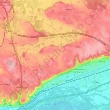
Name: Miribel topographic map, elevation, terrain.
Average elevation: 856 ft
Minimum elevation: 551 ft
Maximum elevation: 1,079 ft
Make a donation
Gear up for your next adventure:
As an Amazon Associate, this site earns from qualifying purchases at no extra cost to you.
Other topographic maps
Click on a map to view its topography, its elevation and its terrain.
Étang des Vosges
France > Auvergne-Rhône-Alpes > Ain > Saint-Germain-sur-Renon > La Maison Neuve
Average elevation: 899 ft
Ardon
France > Auvergne-Rhône-Alpes > Ain > Valserhône > Châtillon-en-Michaille
Average elevation: 2,149 ft
Make a donation
Gear up for your next adventure:
As an Amazon Associate, this site earns from qualifying purchases at no extra cost to you.
Le Raimont
France > Auvergne-Rhône-Alpes > Ain > Valserhône > Châtillon-en-Michaille > Ochiaz
Average elevation: 3,868 ft