
Colgate topographic map
Click on the map to display elevation.
About this map
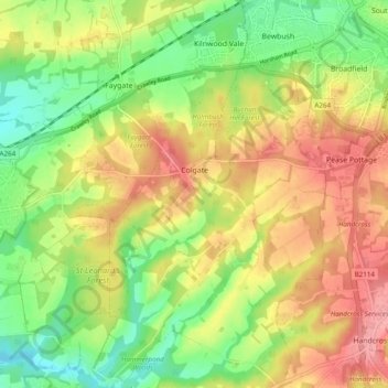
Name: Colgate topographic map, elevation, terrain.
Location: Colgate, Horsham, West Sussex, England, United Kingdom (51.04705 -0.29240 51.10787 -0.21087)
Average elevation: 335 ft
Minimum elevation: 167 ft
Maximum elevation: 515 ft
Other topographic maps
Click on a map to view its topography, its elevation and its terrain.
Smock Alley
United Kingdom > England > West Sussex > Horsham > West Chiltington
Average elevation: 125 ft
Wickhurst Green
United Kingdom > England > West Sussex > Horsham > Wickhurst Green
Average elevation: 148 ft