
Make a donation
Gear up for your next adventure:
As an Amazon Associate, this site earns from qualifying purchases at no extra cost to you.
Palenque topographic map
Click on the map to display elevation.
Make a donation
Gear up for your next adventure:
As an Amazon Associate, this site earns from qualifying purchases at no extra cost to you.
Palenque
The municipality borders the municipalities of Catazajá, La Libertad, Ocosingo, Chilán and Salto de Agua. It also borders the state of Tabasco and Guatemala to the east. Aside from the municipal seat, other important communities include Río Chancala, Bajadas Grandes. Agua Blanca Serranía, Dr. Samuel León Brindis, Nueva Esperanza Primera Sección, Lázaro Cárdenas, Emilio Rabasa and El Naranjo. The city as an altitude of sixty meters above sea level.
Make a donation
Gear up for your next adventure:
As an Amazon Associate, this site earns from qualifying purchases at no extra cost to you.
About this map
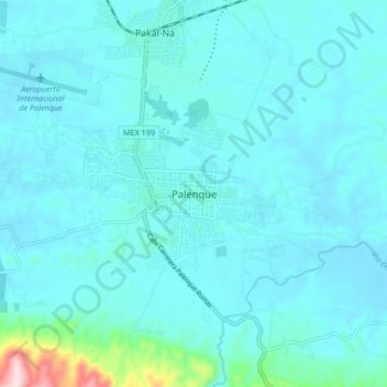
Name: Palenque topographic map, elevation, terrain.
Location: Palenque, Chiapas, 29960, Mexico (17.46919 -92.02092 17.54919 -91.94092)
Average elevation: 253 ft
Minimum elevation: 135 ft
Maximum elevation: 1,394 ft
Make a donation
Gear up for your next adventure:
As an Amazon Associate, this site earns from qualifying purchases at no extra cost to you.