
Bouâaklane topographic map
Interactive map
Click on the map to display elevation.
About this map
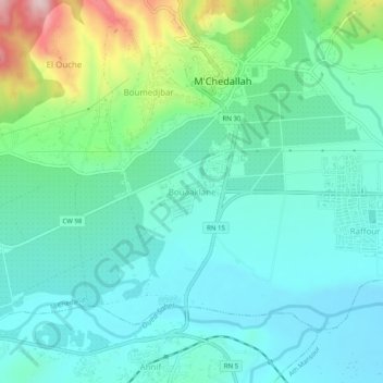
Name: Bouâaklane topographic map, elevation, terrain.
Location: Bouâaklane, M'Chedallah, Daïra M'Chedallah, Bouira, Algérie (36.33310 4.24718 36.37310 4.28718)
Average elevation: 1,217 ft
Minimum elevation: 978 ft
Maximum elevation: 2,018 ft
Other topographic maps
Click on a map to view its topography, its elevation and its terrain.
Raffour
Algérie > Bouira > Daïra M'Chedallah > M'Chedallah
Raffour, M'Chedallah, Daïra M'Chedallah, Bouira, 10019, Algérie
Average elevation: 1,109 ft