
Rockvale Township topographic map
Interactive map
Click on the map to display elevation.
About this map
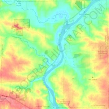
Name: Rockvale Township topographic map, elevation, terrain.
Location: Rockvale Township, Ogle County, Illinois, United States (42.02829 -89.39417 42.11656 -89.27627)
Average elevation: 784 ft
Minimum elevation: 669 ft
Maximum elevation: 938 ft
Other topographic maps
Click on a map to view its topography, its elevation and its terrain.
Grand Detour
United States > Illinois > Ogle County
Grand Detour, Grand Detour Township, Ogle County, Illinois, United States
Average elevation: 699 ft
Oregon
United States > Illinois > Ogle County
Oregon, Oregon - Nashua Township, Ogle County, Illinois, 61061, United States
Average elevation: 732 ft
Stillman Valley
United States > Illinois > Ogle County
Stillman Valley, Marion Township, Ogle County, Illinois, United States
Average elevation: 728 ft
Lost Nation
United States > Illinois > Ogle County
Lost Nation, Taylor Township, Ogle County, Illinois, United States
Average elevation: 732 ft
Leaf River
United States > Illinois > Ogle County
Leaf River, Leaf River Township, Ogle County, Illinois, United States
Average elevation: 745 ft
Monroe Township
United States > Illinois > Ogle County
Monroe Township, Ogle County, Illinois, 61052, United States
Average elevation: 797 ft
Byron
United States > Illinois > Ogle County > Byron
Byron, Ogle County, Illinois, 61010, United States
Average elevation: 741 ft
Monroe Center
United States > Illinois > Ogle County
Monroe Center, Monroe Township, Ogle County, Illinois, United States
Average elevation: 833 ft
Rochelle
United States > Illinois > Ogle County
Rochelle, Flagg Township, Ogle County, Illinois, 61068, United States
Average elevation: 797 ft