
Río Congo topographic map
Interactive map
Click on the map to display elevation.
About this map
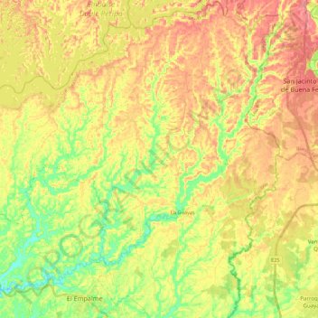
Name: Río Congo topographic map, elevation, terrain.
Location: Río Congo, El Empalme, Guayas, 120602, Ecuador (-1.05412 -79.71446 -0.84122 -79.49706)
Average elevation: 256 ft
Minimum elevation: 108 ft
Maximum elevation: 384 ft
Other topographic maps
Click on a map to view its topography, its elevation and its terrain.
La Majada
Ecuador > Guayas > Santa Lucía > Santa Lucía
La Majada, Santa Lucía, Guayas, Ecuador
Average elevation: 72 ft
Río Trinidad
Ecuador > Guayas > San Carlos
Río Trinidad, San Carlos, Naranjal, Guayas, Ecuador
Average elevation: 256 ft