
Covas topographic map
Interactive map
Click on the map to display elevation.
About this map
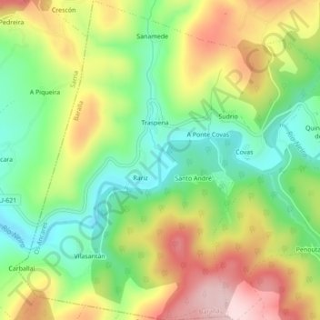
Name: Covas topographic map, elevation, terrain.
Location: Covas, Baralla, Os Ancares, Lugo, Galiza, Espanha (42.84774 -7.33539 42.87938 -7.29398)
Average elevation: 1,768 ft
Minimum elevation: 1,358 ft
Maximum elevation: 2,306 ft
Other topographic maps
Click on a map to view its topography, its elevation and its terrain.
Teixeira
Espanha > Galiza > Os Ancares > Baralla
Teixeira, Baralla, Os Ancares, Lugo, Galiza, 27687, Espanha
Average elevation: 2,257 ft
Guimarei
Espanha > Galiza > Os Ancares > Baralla
Guimarei, Baralla, Os Ancares, Lugo, Galiza, Espanha
Average elevation: 2,474 ft