
Injil topographic map
Interactive map
Click on the map to display elevation.
About this map
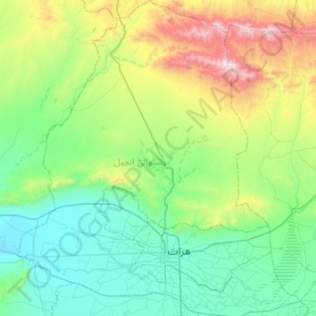
Name: Injil topographic map, elevation, terrain.
Location: Injil, Herat Province, Afghanistan (34.25324 61.92493 34.72170 62.43217)
Average elevation: 4,131 ft
Minimum elevation: 2,812 ft
Maximum elevation: 8,507 ft
Other topographic maps
Click on a map to view its topography, its elevation and its terrain.
Gaza
Afghanistan > Herat Province > Ghurian > Gaza
Gaza, Ghurian, Herat Province, Afghanistan
Average elevation: 2,579 ft
Herat
Herat, Herat Province, 3005, Afghanistan
Average elevation: 3,419 ft