
Stadtoldendorf topographic map
Interactive map
Click on the map to display elevation.
About this map
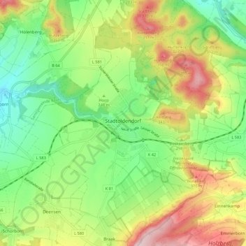
Name: Stadtoldendorf topographic map, elevation, terrain.
Average elevation: 853 ft
Minimum elevation: 476 ft
Maximum elevation: 1,414 ft
Other topographic maps
Click on a map to view its topography, its elevation and its terrain.
Lenne
Duitsland > Nedersaksen > Landkreis Holzminden
Lenne, Samtgemeinde Eschershausen-Stadtoldendorf, Landkreis Holzminden, Nedersaksen, Duitsland
Average elevation: 820 ft
Halle
Duitsland > Nedersaksen > Landkreis Holzminden > Halle
Halle, Samtgemeinde Bodenwerder-Polle, Landkreis Holzminden, Nedersaksen, 37620, Duitsland
Average elevation: 538 ft