
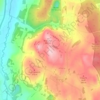
Bryn Alyn topographic map
Interactive map
Click on the map to display elevation.
About this map
Name: Bryn Alyn topographic map, elevation, terrain.
Average elevation: 1,017 ft
Minimum elevation: 643 ft
Maximum elevation: 1,325 ft
Other topographic maps
Click on a map to view its topography, its elevation and its terrain.
River Clwyd
United Kingdom > Wales > St Asaph
River Clwyd, St Asaph, Denbighshire, Wales, LL18 5RL, United Kingdom
Average elevation: 43 ft
Groesffordd Marli
United Kingdom > Wales > St Asaph > Groesffordd Marli
Groesffordd Marli, St Asaph, Denbighshire, Wales, LL22 9DS, United Kingdom
Average elevation: 269 ft
Tai Cochion
United Kingdom > Wales > St Asaph > Tai Cochion
Tai Cochion, St Asaph, Denbighshire, Wales, LL17 0AG, United Kingdom
Average elevation: 141 ft
Cyrn-y-Brain
United Kingdom > Wales > St Asaph
Cyrn-y-Brain, St Asaph, Denbighshire, Wales, LL11 3BG, United Kingdom
Average elevation: 1,483 ft
Eglwyseg River
United Kingdom > Wales > St Asaph
Eglwyseg River, St Asaph, Denbighshire, Wales, LL20 8EE, United Kingdom
Average elevation: 594 ft
River Elwy
United Kingdom > Wales > St Asaph
River Elwy, St Asaph, Denbighshire, Wales, LL17 0HD, United Kingdom
Average elevation: 351 ft