
Lubbia di Sotto topographic map
Interactive map
Click on the map to display elevation.
About this map
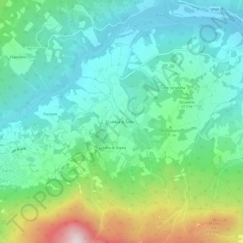
Name: Lubbia di Sotto topographic map, elevation, terrain.
Location: Lubbia di Sotto, Varsi, Parma, Emilia-Romagna, 43049, Italia (44.65022 9.85317 44.69022 9.89317)
Average elevation: 1,617 ft
Minimum elevation: 817 ft
Maximum elevation: 3,852 ft
Other topographic maps
Click on a map to view its topography, its elevation and its terrain.
Tosca
Italia > Emilia-Romagna > Parma > Varsi
Tosca, Varsi, Parma, Emilia-Romagna, Italia
Average elevation: 2,234 ft
Contile
Italia > Emilia-Romagna > Parma > Varsi
Contile, Varsi, Parma, Emilia-Romagna, 43049, Italia
Average elevation: 2,037 ft