
حي الشرطة topographic map
Interactive map
Click on the map to display elevation.
About this map
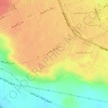
Name: حي الشرطة topographic map, elevation, terrain.
Average elevation: 151 ft
Minimum elevation: 46 ft
Maximum elevation: 217 ft
Other topographic maps
Click on a map to view its topography, its elevation and its terrain.
Al-Najaf District
Al-Najaf District, Al-Najaf Governorate, Iraq
Average elevation: 778 ft
Al-Shabaka
Al-Shabaka, Al-Shabaka Subdistrict, Al-Najaf District, Al-Najaf Governorate, Iraq
Average elevation: 968 ft
Al-Najaf
Al-Najaf, Al-Najaf Central Subdistrict, Al-Najaf District, Al-Najaf Governorate, 54001, Iraq
Average elevation: 98 ft