
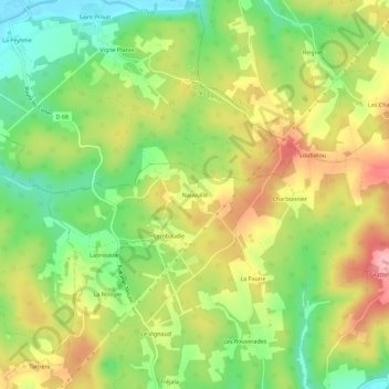
Nauvialle topographic map
Interactive map
Click on the map to display elevation.
About this map
Name: Nauvialle topographic map, elevation, terrain.
Average elevation: 581 ft
Minimum elevation: 354 ft
Maximum elevation: 840 ft
Other topographic maps
Click on a map to view its topography, its elevation and its terrain.
Le Vignaud
France > Nouvelle-Aquitaine > Dordogne > Cubjac-Auvézère-Val d'Ans
Le Vignaud, Cubjac, Cubjac-Auvézère-Val d'Ans, Nontron, Dordogne, Nouvelle-Aquitaine, France métropolitaine, 24640, France
Average elevation: 554 ft
Cubjac
France > Nouvelle-Aquitaine > Dordogne > Cubjac-Auvézère-Val d'Ans
Cubjac, Cubjac-Auvézère-Val d'Ans, Nontron, Dordogne, Nouvelle-Aquitaine, France métropolitaine, 24640, France
Average elevation: 531 ft
Le Château
France > Nouvelle-Aquitaine > Dordogne > Cubjac-Auvézère-Val d'Ans
Le Château, Cubjac, Cubjac-Auvézère-Val d'Ans, Nontron, Dordogne, Nouvelle-Aquitaine, France métropolitaine, 24640, France
Average elevation: 525 ft
Rodas
France > Nouvelle-Aquitaine > Dordogne > Cubjac-Auvézère-Val d'Ans
Rodas, Cubjac, Cubjac-Auvézère-Val d'Ans, Nontron, Dordogne, Nouvelle-Aquitaine, France métropolitaine, 24640, France
Average elevation: 528 ft
Cubjac
France > Nouvelle-Aquitaine > Dordogne > Cubjac-Auvézère-Val d'Ans
Cubjac, Cubjac-Auvézère-Val d'Ans, Nontron, Dordogne, Nouvelle-Aquitaine, France métropolitaine, 24640, France
Average elevation: 545 ft