
Kampenwand-Hauptgipfel topographic map
Interactive map
Click on the map to display elevation.
About this map
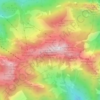
Name: Kampenwand-Hauptgipfel topographic map, elevation, terrain.
Average elevation: 4,173 ft
Minimum elevation: 2,812 ft
Maximum elevation: 5,305 ft
Other topographic maps
Click on a map to view its topography, its elevation and its terrain.
Hammerbach
Deutschland > Bayern > Landkreis Rosenheim > Aschau im Chiemgau
Hammerbach, Aschau im Chiemgau, Landkreis Rosenheim, Bayern, 83229, Deutschland
Average elevation: 2,858 ft
Hohenaschau
Deutschland > Bayern > Landkreis Rosenheim > Aschau im Chiemgau
Hohenaschau, Aschau im Chiemgau, Landkreis Rosenheim, Bayern, 83229, Deutschland
Average elevation: 2,831 ft
Goriloch
Deutschland > Bayern > Landkreis Rosenheim > Aschau im Chiemgau > Goriloch
Goriloch, Aschau im Chiemgau, Landkreis Rosenheim, Bayern, 83229, Deutschland
Average elevation: 3,625 ft
Geigelstein
Deutschland > Bayern > Landkreis Rosenheim > Aschau im Chiemgau
Geigelstein, Aschau im Chiemgau, Landkreis Rosenheim, Bayern, Deutschland
Average elevation: 4,734 ft
Kohlstatt
Deutschland > Bayern > Landkreis Rosenheim > Aschau im Chiemgau > Kohlstatt
Kohlstatt, Aschau im Chiemgau, Landkreis Rosenheim, Bayern, 83229, Deutschland
Average elevation: 2,602 ft
Staffelstein
Deutschland > Bayern > Landkreis Rosenheim > Aschau im Chiemgau
Staffelstein, Aschau im Chiemgau, Landkreis Rosenheim, Bayern, Deutschland
Average elevation: 4,127 ft