
North Glendale topographic map
Interactive map
Click on the map to display elevation.
About this map
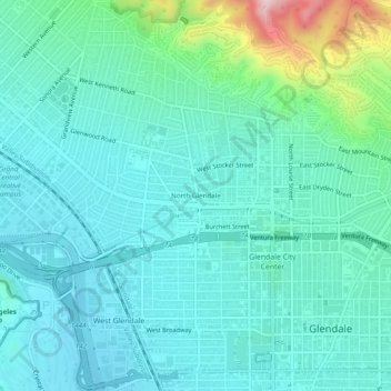
Name: North Glendale topographic map, elevation, terrain.
Average elevation: 643 ft
Minimum elevation: 417 ft
Maximum elevation: 1,657 ft
Other topographic maps
Click on a map to view its topography, its elevation and its terrain.
Adams Square
United States > California > Los Angeles County > Glendale > Adams Square
Adams Square, Glendale, Los Angeles County, California, 91205, United States
Average elevation: 551 ft
Verdugo City
United States > California > Los Angeles County > Glendale
Verdugo City, Glendale, Los Angeles County, California, 91046, United States
Average elevation: 1,549 ft