
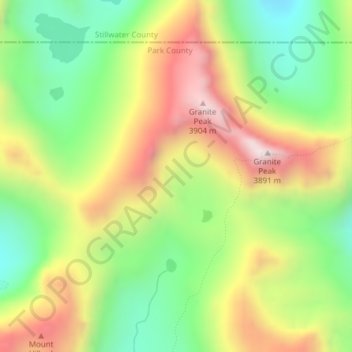
Sky Top Glacier topographic map
Interactive map
Click on the map to display elevation.
About this map
Name: Sky Top Glacier topographic map, elevation, terrain.
Location: Sky Top Glacier, Park County, Montana, USA (45.16156 -109.81745 45.16166 -109.81735)
Average elevation: 11,286 ft
Minimum elevation: 10,085 ft
Maximum elevation: 12,776 ft
Other topographic maps
Click on a map to view its topography, its elevation and its terrain.
Beaverhead-Deerlodge National Forest
Beaverhead-Deerlodge National Forest, Gravelly Range Road, Madison County, Montana, USA
Average elevation: 6,575 ft
Fort Peck Lake
USA > Montana > Park Grove
Fort Peck Lake, MT 117, Park Grove, Valley County, Montana, 59248, USA
Average elevation: 2,073 ft
Going-to-the-Sun Mountain
Going-to-the-Sun Mountain, Glacier County, Montana, USA
Average elevation: 6,919 ft
Westside Reservoir Park
Westside Reservoir Park, Butte, Silver Bow County, Montana, 59703, USA
Average elevation: 5,948 ft
Cabinet Mountains Wilderness Area
Cabinet Mountains Wilderness Area, Sanders County, Montana, USA
Average elevation: 4,091 ft
Mission Mountains Tribal Wilderness
Mission Mountains Tribal Wilderness, McDonald Lake Road, Lake County, Montana, USA
Average elevation: 4,537 ft
Capital Hill
Capital Hill, Boulder, Jefferson County, Montana, 59632, USA
Average elevation: 4,928 ft
Wurtz Hill
USA > Montana > Wurtz Hill
Wurtz Hill, Flathead County, Montana, USA
Average elevation: 3,924 ft
East Helena
USA > Montana > East Helena
East Helena, Lewis and Clark County, Montana, USA
Average elevation: 3,894 ft
Sarcee Mountain
Sarcee Mountain, Glacier County, Montana, USA
Average elevation: 6,739 ft
Margaret Lake
Margaret Lake, Mokowanis Lake, Glacier County, Montana, USA
Average elevation: 6,506 ft
Mahtotopa Mountain
Mahtotopa Mountain, Glacier County, Montana, USA
Average elevation: 7,047 ft
Gem Glacier
Gem Glacier, Highline Trail, Flathead County, Montana, USA
Average elevation: 7,054 ft
Cloudcroft Peaks
Cloudcroft Peaks, Flathead County, Montana, USA
Average elevation: 6,673 ft
Fairy Lake
Fairy Lake, Fairy Lake Access Trail, Gallatin County, Montana, USA
Average elevation: 8,022 ft
Haugan Mountain
Haugan Mountain, Mineral County, Montana, 59867, USA
Average elevation: 3,960 ft
Wahcheechee Mountain
Wahcheechee Mountain, Glacier County, Montana, USA
Average elevation: 6,998 ft
North Swiftcurrent Glacier
North Swiftcurrent Glacier, Swiftcurrent Lookout Trail, Flathead County, Montana, USA
Average elevation: 6,729 ft
Wolftail Mountain
Wolftail Mountain, Flathead County, Montana, USA
Average elevation: 6,699 ft
Kupunkamint Mountain
Kupunkamint Mountain, Glacier County, Montana, USA
Average elevation: 7,421 ft
Lewis and Clark National Forest
Lewis and Clark National Forest, Moose Creek Road, Meagher County, Montana, USA
Average elevation: 4,390 ft
Curly Bear Mountain
Curly Bear Mountain, Pondera County, Montana, USA
Average elevation: 6,588 ft
Brave Dog Mountain
Brave Dog Mountain, Flathead County, Montana, USA
Average elevation: 6,798 ft
Mad Wolf Mountain
Mad Wolf Mountain, Glacier County, Montana, USA
Average elevation: 7,142 ft
Beartooth Glacier
Beartooth Glacier, Carbon County, Montana, USA
Average elevation: 10,630 ft
Upper Missouri River Breaks National Monument
Upper Missouri River Breaks National Monument, Fergus County, Montana, USA
Average elevation: 3,291 ft
Grasshopper Glacier
Grasshopper Glacier, Carbon County, Montana, USA
Average elevation: 11,178 ft
Fusillade Mountain
Fusillade Mountain, Glacier County, Montana, USA
Average elevation: 6,634 ft
Devils Slide
Devils Slide, Many Glacier Road, Babb, Glacier County, Montana, 59411, USA
Average elevation: 4,928 ft
Nemesis Mountain
Nemesis Mountain, Beaverhead County, Montana, USA
Average elevation: 7,959 ft