
Wurtz Hill topographic map
Interactive map
Click on the map to display elevation.
About this map
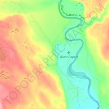
Name: Wurtz Hill topographic map, elevation, terrain.
Location: Wurtz Hill, Flathead County, Montana, USA (48.88386 -114.41042 48.92386 -114.37042)
Average elevation: 3,924 ft
Minimum elevation: 3,720 ft
Maximum elevation: 4,154 ft
Other topographic maps
Click on a map to view its topography, its elevation and its terrain.
Kintla Glacier
USA > Montana > Wurtz Hill
Kintla Glacier, Boulder Pass, Wurtz Hill, Flathead County, Montana, USA
Average elevation: 7,664 ft
Hudson Glacier
USA > Montana > Wurtz Hill
Hudson Glacier, Boulder Pass, Wurtz Hill, Flathead County, Montana, USA
Average elevation: 6,821 ft
Dixon Glacier
USA > Montana > Wurtz Hill
Dixon Glacier, Boulder Pass, Wurtz Hill, Flathead County, Montana, USA
Average elevation: 7,192 ft
Agassiz Glacier
USA > Montana > Wurtz Hill
Agassiz Glacier, Boulder Pass, Wurtz Hill, Flathead County, Montana, USA
Average elevation: 7,795 ft
Harris Glacier
USA > Montana > Wurtz Hill
Harris Glacier, Boulder Pass, Wurtz Hill, Flathead County, Montana, USA
Average elevation: 7,014 ft
Boulder Glacier
USA > Montana > Wurtz Hill
Boulder Glacier, Boulder Pass, Wurtz Hill, Flathead County, Montana, USA
Average elevation: 6,906 ft
Herbst Glacier
USA > Montana > Wurtz Hill
Herbst Glacier, Boulder Pass, Wurtz Hill, Flathead County, Montana, USA
Average elevation: 6,624 ft