
Castellciutat topographic map
Interactive map
Click on the map to display elevation.
About this map
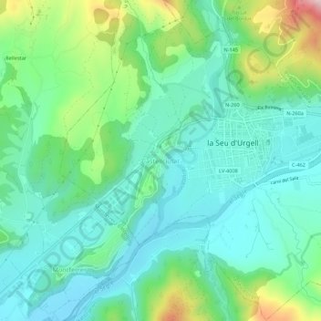
Name: Castellciutat topographic map, elevation, terrain.
Average elevation: 2,461 ft
Minimum elevation: 2,126 ft
Maximum elevation: 3,432 ft
Other topographic maps
Click on a map to view its topography, its elevation and its terrain.
Castell de Ciutat
España > Cataluña > Alto Urgel > Seo de Urgel > Castellciutat
Castell de Ciutat, Cami d'entrada a Castellciutat, Barri de Santa Magdalena, Castellciutat, Seo de Urgel, Alto Urgel, Cataluña, 25710, España
Average elevation: 2,405 ft