
Make a donation
Gear up for your next adventure:
As an Amazon Associate, this site earns from qualifying purchases at no extra cost to you.
Montauroux topographic map
Click on the map to display elevation.
Make a donation
Gear up for your next adventure:
As an Amazon Associate, this site earns from qualifying purchases at no extra cost to you.
Montauroux
Montauroux is situated in the east of the Var and at the border of the Alpes-Maritimes. Montauroux rises in tiers of altitudes from 150 m to 400 m. The village has a southern exposure, facing the Esterel massif and the St Cassien Lake. Montauroux is located midway between the sea which is 30 km (19 mi) away and the first ski resort which is 40 km (25 mi), away. Montauroux benefits from an exceptional amount of sunny days and is visited by tourists in the summer months, many hotels are often fully booked for the summer by mid-April or earlier.
Make a donation
Gear up for your next adventure:
As an Amazon Associate, this site earns from qualifying purchases at no extra cost to you.
About this map
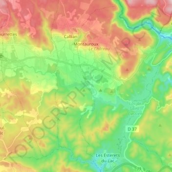
Name: Montauroux topographic map, elevation, terrain.
Average elevation: 850 ft
Minimum elevation: 266 ft
Maximum elevation: 1,699 ft
Make a donation
Gear up for your next adventure:
As an Amazon Associate, this site earns from qualifying purchases at no extra cost to you.
Other topographic maps
Click on a map to view its topography, its elevation and its terrain.
Le Canadel
France > Provence-Alpes-Côte d'Azur > Var > Rayol-Canadel-sur-Mer
Average elevation: 443 ft
Le Camp du Castellet
France > Provence-Alpes-Côte d'Azur > Var > Le Castellet
Average elevation: 1,217 ft
Make a donation
Gear up for your next adventure:
As an Amazon Associate, this site earns from qualifying purchases at no extra cost to you.
forêt de Sainte barbe
France > Provence-Alpes-Côte d'Azur > Var > Draguignan
Average elevation: 771 ft
Make a donation
Gear up for your next adventure:
As an Amazon Associate, this site earns from qualifying purchases at no extra cost to you.
Ruines du Barrage de Malpasset
France > Provence-Alpes-Côte d'Azur > Var > Fréjus
Average elevation: 387 ft
Val d'Esquieres
France > Provence-Alpes-Côte d'Azur > Var > Roquebrune-sur-Argens
Average elevation: 269 ft
Plage de Bonporteau
France > Provence-Alpes-Côte d'Azur > Var > Cavalaire-sur-Mer
Average elevation: 135 ft
Make a donation
Gear up for your next adventure:
As an Amazon Associate, this site earns from qualifying purchases at no extra cost to you.
Make a donation
Gear up for your next adventure:
As an Amazon Associate, this site earns from qualifying purchases at no extra cost to you.
Le Plan
France > Provence-Alpes-Côte d'Azur > Var > Plan-d'Aups-Sainte-Baume
Average elevation: 2,362 ft
Make a donation
Gear up for your next adventure:
As an Amazon Associate, this site earns from qualifying purchases at no extra cost to you.
Margin
France > Provence-Alpes-Côte d'Azur > Var > Vinon-sur-Verdon > Margin
Average elevation: 1,079 ft
Les Aires Longues
France > Provence-Alpes-Côte d'Azur > Var > Ginasservis > Les Aires Longues
Average elevation: 1,348 ft
Draguignan
France > Provence-Alpes-Côte d'Azur > Var > Draguignan > Draguignan
The elevation is 200 m. The highest hill near Draguignan is Malmont (551 m). The main river near Draguignan is the Nartuby.
Average elevation: 945 ft
Make a donation
Gear up for your next adventure:
As an Amazon Associate, this site earns from qualifying purchases at no extra cost to you.
Île des Embiez
France > Provence-Alpes-Côte d'Azur > Var > Six-Fours-les-Plages > Le Brusc
Average elevation: 7 ft
Fort de Brégançon
France > Provence-Alpes-Côte d'Azur > Var > Bormes-les-Mimosas
Average elevation: 30 ft
Jospeh Allet
France > Provence-Alpes-Côte d'Azur > Var > Draguignan > Draguignan > Saint François
Average elevation: 679 ft
Make a donation
Gear up for your next adventure:
As an Amazon Associate, this site earns from qualifying purchases at no extra cost to you.
Château de La Verdière
France > Provence-Alpes-Côte d'Azur > Var > La Verdière
Average elevation: 1,444 ft