Geolocate

Santa Rosa topographic map

Click on the map to display elevation.

About this map

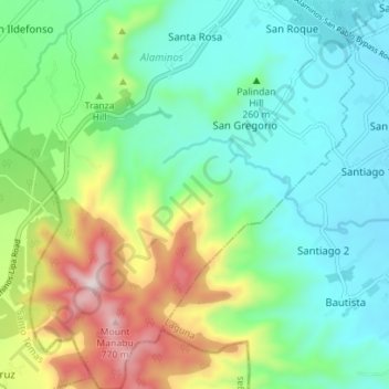
Name: Santa Rosa topographic map, elevation, terrain.

Location: Santa Rosa, Alaminos, Laguna, Calabarzon, 4001, Philippines (13.98195 121.22082 14.04990 121.26173)

Average elevation: 876 ft

Minimum elevation: 213 ft

Maximum elevation: 2,500 ft

Gear up for your next adventure:

📦Gear Storage Bags - Organize and protect outdoor equipment
🔥Fast-Boil Camping Stoves - Efficient cooking systems for quick trail meals
🧴Hand Sanitizer - Keep hands clean while hiking
🪶Wildlife Field Guides - Learn animal tracking and species ID
🌲Outdoor Survival Books - Best books on survival skills

As an Amazon Associate, this site earns from qualifying purchases at no extra cost to you.