
Jiali District topographic map
Interactive map
Click on the map to display elevation.
About this map
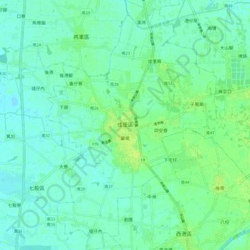
Name: Jiali District topographic map, elevation, terrain.
Location: Jiali District, Tainan, 722, Taiwan (23.11638 120.14470 23.21334 120.21584)
Average elevation: 16 ft
Minimum elevation: -7 ft
Maximum elevation: 39 ft
Other topographic maps
Click on a map to view its topography, its elevation and its terrain.
嘉南
Taiwan > Tainan > Guantian District
嘉南, Wushantou Village, Guantian District, Tainan, 720, Taiwan
Average elevation: 154 ft
Fengguizui
Taiwan > Tainan > Nanhua District > Fengguizui
Fengguizui, Yushan Village, Nanhua District, Tainan, 716, Taiwan
Average elevation: 738 ft
Niuzhuang
Taiwan > Tainan > Shanhua District > Niuzhuang
Niuzhuang, Niuzhuang Village, Shanhua District, Tainan, 741, Taiwan
Average elevation: 59 ft