
Ligonier topographic map
Interactive map
Click on the map to display elevation.
About this map
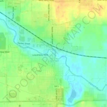
Name: Ligonier topographic map, elevation, terrain.
Location: Ligonier, Noble County, Indiana, United States (41.45034 -85.61066 41.48133 -85.57830)
Average elevation: 909 ft
Minimum elevation: 860 ft
Maximum elevation: 968 ft
Other topographic maps
Click on a map to view its topography, its elevation and its terrain.
Chain O'Lakes State Park
United States > Indiana > Noble County
Chain O'Lakes State Park, 9, Noble County, Indiana, United States
Average elevation: 951 ft
Avilla
United States > Indiana > Noble County
Avilla, Noble County, Indiana, United States
Average elevation: 965 ft
Kendallville
United States > Indiana > Noble County
Kendallville, Noble County, Indiana, 46755, United States
Average elevation: 994 ft
Albion
United States > Indiana > Noble County
Albion, Noble County, Indiana, United States
Average elevation: 935 ft
Kendallville
United States > Indiana > Noble County > Kendallville > Kendallville
Kendallville, Noble County, Indiana, 46755, United States
Average elevation: 997 ft
Wolcottville
United States > Indiana > Noble County
Wolcottville, Noble County, Indiana, United States
Average elevation: 942 ft