
Kagbeni topographic map
Interactive map
Click on the map to display elevation.
About this map
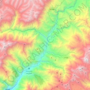
Name: Kagbeni topographic map, elevation, terrain.
Average elevation: 16,447 ft
Minimum elevation: 8,478 ft
Maximum elevation: 23,556 ft
Der Ort Kagbeni liegt am linken Ufer des Kali Gandaki auf einer Höhe von 2830 m an der Einmündung des Nebenflusses Jhong Khola. Der Ort liegt an der Straße vom knapp 10 km südlich gelegenen Jomsom zum 10 km östlich gelegenen Muktinath.
Other topographic maps
Click on a map to view its topography, its elevation and its terrain.
Lamanthang
Nepal > मुस्ताङ > Lomanthang
Lamanthang, Lomanthang, मुस्ताङ, Provinz Gandaki, Nepal
Average elevation: 16,073 ft
Sekung Lake
Nepal > मुस्ताङ > Kowang > Naurikot
Sekung Lake, Dhaulagiri Ice Fall route, Naurikot, Kowang, Thasang, मुस्ताङ, Provinz Gandaki, Nepal
Average elevation: 9,455 ft