
Hartsville topographic map
Interactive map
Click on the map to display elevation.
About this map
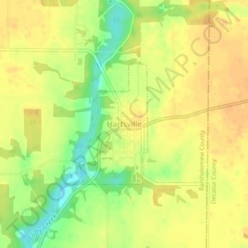
Name: Hartsville topographic map, elevation, terrain.
Location: Hartsville, Bartholomew County, Indiana, United States (39.26150 -85.70562 39.27471 -85.69511)
Average elevation: 755 ft
Minimum elevation: 682 ft
Maximum elevation: 791 ft
Other topographic maps
Click on a map to view its topography, its elevation and its terrain.
North Gate
United States > Indiana > Bartholomew County
North Gate, Bartholomew County, Indiana, 47280, United States
Average elevation: 646 ft
Haw Creek
United States > Indiana > Bartholomew County > Hope
Haw Creek, Hope, Bartholomew County, Indiana, United States
Average elevation: 686 ft
Columbus
United States > Indiana > Bartholomew County
Columbus, Bartholomew County, Indiana, United States
Average elevation: 646 ft
Hope
United States > Indiana > Bartholomew County > Hope
Hope, Bartholomew County, Indiana, United States
Average elevation: 725 ft
Corn Brook
United States > Indiana > Bartholomew County > Columbus > Corn Brook
Corn Brook, Columbus, Bartholomew County, Indiana, United States
Average elevation: 643 ft