
Make a donation
Gear up for your next adventure:
As an Amazon Associate, this site earns from qualifying purchases at no extra cost to you.
Wading River topographic map
Click on the map to display elevation.
Make a donation
Gear up for your next adventure:
As an Amazon Associate, this site earns from qualifying purchases at no extra cost to you.
Wading River
The earliest English records show a settlement known as Wading River was founded by eight colonial families. "The spot for the village was chosen with care. There was a stream adequate for water power and abounding in seafood...good water for drinking...soil rich enough to grow essential crops, woodland for fuel, building material and food, topography to offer protection from the elements, meadowland for its grass."
Make a donation
Gear up for your next adventure:
As an Amazon Associate, this site earns from qualifying purchases at no extra cost to you.
About this map
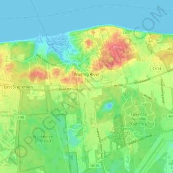
Name: Wading River topographic map, elevation, terrain.
Average elevation: 75 ft
Minimum elevation: -13 ft
Maximum elevation: 217 ft
Suffolk County trails, hiking, mountain biking, running and outdoor activities
Make a donation
Gear up for your next adventure:
As an Amazon Associate, this site earns from qualifying purchases at no extra cost to you.
Other topographic maps
Click on a map to view its topography, its elevation and its terrain.