
Distrito Central topographic map
Interactive map
Click on the map to display elevation.
About this map
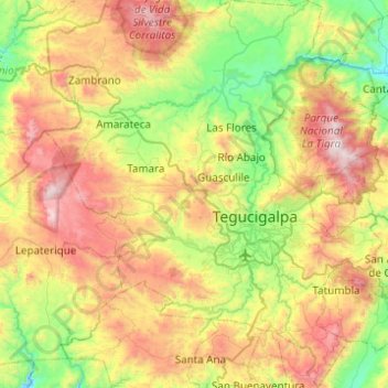
Name: Distrito Central topographic map, elevation, terrain.
Location: Distrito Central, Francisco Morazán, Honduras (13.89506 -87.47228 14.37191 -87.00542)
Average elevation: 4,222 ft
Minimum elevation: 2,159 ft
Maximum elevation: 7,556 ft
Other topographic maps
Click on a map to view its topography, its elevation and its terrain.
Tegucigalpa
Honduras > Francisco Morazán > Distrito Central
Tegucigalpa, Distrito Central, Francisco Morazán, Honduras
Average elevation: 3,786 ft