
Anini topographic map
Interactive map
Click on the map to display elevation.
Anini
The small settlement of Anini is located at an elevation of 1,968 metres (6,457 ft) above sea level. On the Aninese Plateau, the average elevation is 1,800 meters, but the average elevation of the town is 2,068 meters. According to Google Maps' terrain feature, Anini is around 1,600–1,800 meters above sea level and up north of Anini, the elevation can go up to 3,800 meters above sea level. According to the official website of the Dibang Valley District, Anini's altitude is at 1,968 meters above sea level.
About this map
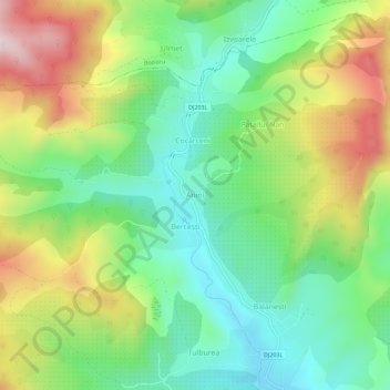
Name: Anini topographic map, elevation, terrain.
Location: Anini, Cozieni, Buzău, 127211, Romania (45.33234 26.45456 45.37234 26.49456)
Average elevation: 1,427 ft
Minimum elevation: 850 ft
Maximum elevation: 2,388 ft
Other topographic maps
Click on a map to view its topography, its elevation and its terrain.
Buzău
The city is located in the center of the county, 100 km north-east of Bucharest, in the South-East of Romania, taking up a total area of 81,3 km2, at the outermost curvature of the Subcarpathian foothills, at the crossroads of the three main Romanian historical provinces: Wallachia, Transylvania and Moldavia.…
Average elevation: 315 ft