
Ighil N'Oumgoun topographic map
Interactive map
Click on the map to display elevation.
About this map
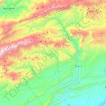
Name: Ighil N'Oumgoun topographic map, elevation, terrain.
Average elevation: 7,680 ft
Minimum elevation: 4,849 ft
Maximum elevation: 13,228 ft
Other topographic maps
Click on a map to view its topography, its elevation and its terrain.
gorges de m'Goun
Maroc > cercle de Boulmane-Dadès > Ighil N'Oumgoun
gorges de m'Goun, Ighil N'Oumgoun, caïdat d'Ahl Mgoun, Cercle de Boulmane-Dadès, Province de Tinghir, Drâa-Tafilalet, Maroc
Average elevation: 7,316 ft