
Obergünzburg topographic map
Interactive map
Click on the map to display elevation.
About this map
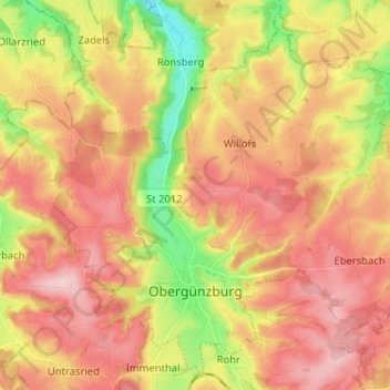
Name: Obergünzburg topographic map, elevation, terrain.
Average elevation: 2,654 ft
Minimum elevation: 2,244 ft
Maximum elevation: 2,969 ft
Other topographic maps
Click on a map to view its topography, its elevation and its terrain.
Füssen
Duitsland > Beieren > Landkreis Ostallgäu
Füssen, Landkreis Ostallgäu, Beieren, 87629, Duitsland
Average elevation: 2,795 ft
Halblech
Duitsland > Beieren > Landkreis Ostallgäu
Halblech, Landkreis Ostallgäu, Beieren, 87642, Duitsland
Average elevation: 3,583 ft
Hohenschwangau
Duitsland > Beieren > Landkreis Ostallgäu > Hohenschwangau
Hohenschwangau, Schwangau, Landkreis Ostallgäu, Beieren, 87645, Duitsland
Average elevation: 3,264 ft
Nesselwang
Duitsland > Beieren > Landkreis Ostallgäu
Nesselwang, Landkreis Ostallgäu, Beieren, 87484, Duitsland
Average elevation: 3,268 ft
Berleberg
Duitsland > Beieren > Landkreis Ostallgäu > Kraftisried > Berleberg
Berleberg, Kraftisried, Unterthingau (VGem), Landkreis Ostallgäu, Beieren, 87647, Duitsland
Average elevation: 2,740 ft
Waal
Duitsland > Beieren > Landkreis Ostallgäu
Waal, Buchloe, Landkreis Ostallgäu, Beieren, 86875, Duitsland
Average elevation: 2,136 ft