
نوشاخ topographic map
Interactive map
Click on the map to display elevation.
About this map
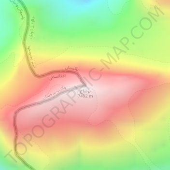
Name: نوشاخ topographic map, elevation, terrain.
Location: نوشاخ, Chitrāl District, Jaiber Pastunjuá, Pakistán (36.43216 71.82991 36.43226 71.83001)
Average elevation: 22,516 ft
Minimum elevation: 19,970 ft
Maximum elevation: 24,491 ft
Other topographic maps
Click on a map to view its topography, its elevation and its terrain.
ایبٹ آباد
ایبٹ آباد, Jaiber Pastunjuá, 22010, Pakistán
Average elevation: 4,472 ft
Mate
Pakistán > Jaiber Pastunjuá > Mate
Mate, Kohistān District, Jaiber Pastunjuá, Pakistán
Average elevation: 4,498 ft
Tirich Mir
Tirich Mir, Chitrāl District, Jaiber Pastunjuá, Pakistán
Average elevation: 22,592 ft
Chitral
Pakistán > Jaiber Pastunjuá > Chitral
Chitral, Chitrāl District, Jaiber Pastunjuá, Pakistán
Average elevation: 6,716 ft
Istor-o-Nal
Istor-o-Nal, Chitrāl District, Jaiber Pastunjuá, Pakistán
Average elevation: 22,484 ft