
Jungsolau topographic map
Interactive map
Click on the map to display elevation.
About this map
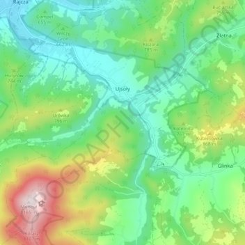
Name: Jungsolau topographic map, elevation, terrain.
Location: Jungsolau, gmina Ujsoły, powiat żywiecki, 34-371, Polen (49.44492 19.08990 49.50338 19.17265)
Average elevation: 2,303 ft
Minimum elevation: 1,640 ft
Maximum elevation: 3,793 ft
Other topographic maps
Click on a map to view its topography, its elevation and its terrain.
Saybusch
Polen > powiat żywiecki > Saybusch
Saybusch, powiat żywiecki, 34-300, Polen
Average elevation: 1,434 ft