
Cañada San Antonio topographic map
Interactive map
Click on the map to display elevation.
About this map
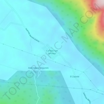
Name: Cañada San Antonio topographic map, elevation, terrain.
Average elevation: 456 ft
Minimum elevation: 220 ft
Maximum elevation: 2,008 ft
Other topographic maps
Click on a map to view its topography, its elevation and its terrain.
Las Maravillas
México > Oaxaca > Acatlán de Pérez Figueroa
Las Maravillas, Acatlán de Pérez Figueroa, Oaxaca, México
Average elevation: 758 ft
Vicente Camalote
México > Oaxaca > Acatlán de Pérez Figueroa > Vicente Camalote
Vicente Camalote, Acatlán de Pérez Figueroa, Oaxaca, 68422, México
Average elevation: 387 ft