
Politg topographic map
Interactive map
Click on the map to display elevation.
About this map
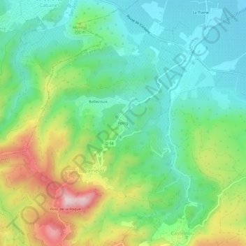
Name: Politg topographic map, elevation, terrain.
Average elevation: 814 ft
Minimum elevation: 394 ft
Maximum elevation: 1,686 ft
Other topographic maps
Click on a map to view its topography, its elevation and its terrain.
Bosc de la Roque
France > Occitanie > Pyrénées-Orientales > Camélas
Bosc de la Roque, Camélas, Céret, Pyrénées-Orientales, Occitanie, France métropolitaine, 66300, France
Average elevation: 1,129 ft
Mas Sainte-Colombe
France > Occitanie > Pyrénées-Orientales > Camélas
Mas Sainte-Colombe, Camélas, Céret, Pyrénées-Orientales, Occitanie, France métropolitaine, 66300, France
Average elevation: 1,033 ft